Terrain Matters: A Focus+Context Visualization Approach for Landform-Based Remote Sensing Analysis of Agricultural Performance
Abstract
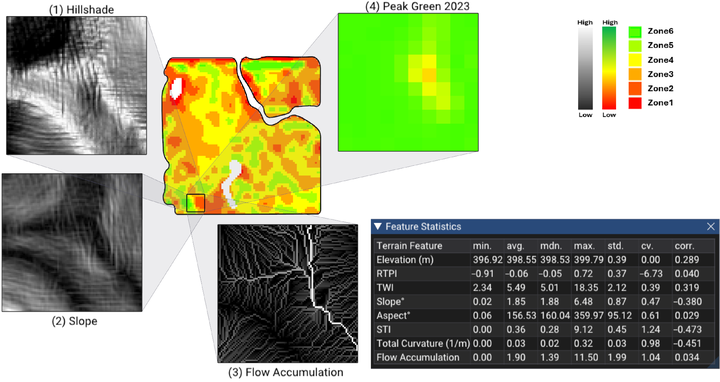
Understanding spatial variability is central to precision agriculture, yet terrain features are often overlooked in remote sensing workflows that inform agronomic decision-making. This work introduces a terrain-aware visual analytics approach that integrates landform classification with crop performance analysis to better support field-level decisions. Terrain features are an important contributor to yield variability, alongside environmental conditions, soil properties, and management practices. However, they are rarely integrated systematically into performance analysis and decision-making workflows—limiting the potential for terrain-aware insights in precision agriculture. Addressing this gap requires approaches that incorporate terrain attributes and landform classifications into agricultural performance analysis and management zone (MZ) delineation—ideally through visual analytics that offer interpretable insights beyond the constraints of purely data-driven methods. We introduce an interactive focus+context visualization tool that integrates multiple data layers—including terrain features, vegetation index–based performance metric, and management zones—into a unified, expressive view. The system leverages freely available remote sensing imagery and terrain data derived from Digital Elevation Models (DEMs) to evaluate crop performance and landform characteristics in support of agronomic analysis. The tool was applied to eleven agricultural fields across the Canadian Prairies under diverse environmental conditions. Fields were segmented into depressions, hilltops, and baseline areas, and crop performance was evaluated across these landform groups using the system’s interactive visualization and analytics. Depressions and hilltops consistently showed lower mean performance and higher variability (measured by coefficient of variation) compared to baseline regions, which covered an average of 82% of each field. We also subdivided baseline areas using slope and the Sediment Transport Index (STI) to investigate soil erosion effects, but field-level patterns were inconsistent and no systematic differences emerged across all sites. Expert evaluation confirmed the tool’s usability and its value for field-level decision support. Overall, the method enhances terrain-aware interpretation of remotely sensed data and contributes meaningfully to refining management zone delineation in precision agriculture.
Roghayeh Heidari
Ph.D. Candidate
September 2021 - present
Roghi is a PhD student interested in computer graphics, and algorithm design.